SRA Annual Report 2020-21: River Sowy – King’s Sedgemoor Drain enhancements
Contents – quick links
Background
Activities in 2020-21
Mitigation and compliance works at Egypt’s Clyse, Moorlinch and Westmoor
Background
The River Sowy is used by the Environment Agency to take excess water away from the River Parrett near Aller. Water flows into the Sowy through the Monk’s Leaze Clyse sluice, goes down via Beer Wall to King’s Sedgemoor Drain (KSD) near Greylake, then re-joins the Parrett at Dunball.
During the floods of 2013-14, after Monk’s Leaze Clyse was opened fully, flood waters fell 80 centimetres in two days. No other single act had such a dramatic effect. It was described by one senior officer as being “like magic”. In wet winters since, the Sowy has again helped to take pressure off the Parrett and allow for earlier and longer pumping.
The Sowy is a man-made river. It was conceived as a Parrett Flood Relief Channel after downpours deluged 50,000 acres of Somerset (including Taunton) in October 1960.
The first plan in 1961 was for a channel that could carry 30 cubic metres of water per second into a widened KSD. After long arguments about cost, the Sowy was scaled back to 17 cubic metres per second (cumecs).
Work started in 1969, and took three years.

However – though the Sowy was built smaller than first suggested – all associated sluices or bridges were built or modified so they could deal with 30 cumecs and the system could be made larger once funding was available in future.
Somerset Rivers Authority is now picking up the possibilities left to us all by an earlier generation.
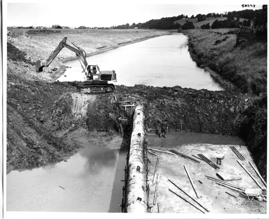
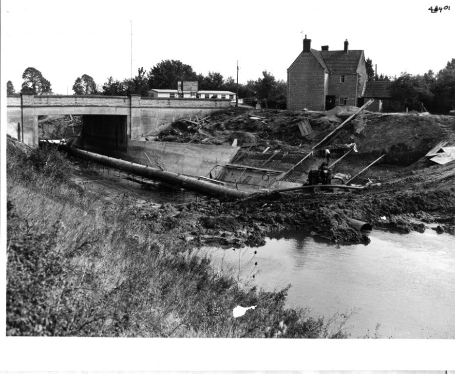
Providing more capacity in the Sowy-KSD system, so that it can be used more effectively, is a key aim of Somerset’s 20 Year Flood Action Plan, which is overseen by the SRA. Sowy-KSD works in recent years have included the creation of new river channels under the busy A372 at Beer Wall along with tilting weirs, to help stop the road flooding as it did for weeks in 2014; the installation of a new water level control gate near Chedzoy, to help better protect the Chedzoy and Andersea area; the removal of obstructive masonry from under Dunball Old Bridge, which carries A38 traffic southbound; and de-silting of bridges to increase channel capacity at Parchey and Dunball.
All these works are part of a programme to reduce flood risks across 150 square miles. Now, as back in the 1960s, the intent is to reduce the risks of flooding – particularly summer flooding – for moors upstream of Langport and some lower roads, and for moors west of the Parrett. Doing this will help to protect people, homes, farms, businesses, land and infrastructure.
Activities during 2020-21
A milestone was reached in August 2020 when the Environmental Statement for the first phase of the River Sowy-King’s Sedgemoor Drain (KSD) Enhancements Scheme went out for public consultation, online because of the coronavirus pandemic. The Environmental Statement’s non-technical summary, 14 chapters and 16 appendices can be read at https://consult.environment-agency.gov.uk/ wessex/river-sowy-and-ksd-enhancements/
In simple terms, the Environmental Statement was legally required to show that the potential impacts of this Scheme had been properly investigated and assessed. The Environmental Statement therefore included many detailed designs to show exactly what works were proposed, and examinations of the Scheme’s effects upon water, flora and fauna, cultural heritage, landscape, population and health and noise. It also looked at the cumulative impacts of different elements. Five responses were received, relevant issues were addressed, and so the Environment Agency determined that the Scheme should proceed.

The Sowy-KSD Enhancements Scheme is being delivered for Somerset Rivers Authority by the Environment Agency and partly funded by Growth Deal money from the Heart of the South West Local Enterprise Partnership (HotSWLEP). In October 2020, HotSWLEP agreed to give the Sowy- KSD Scheme more time to spend its remaining allocation of Growth Deal funding. The deadline was previously the end of March 2021, but Phase One construction activities must now be completed by November 2021.
![]()
![]()
The Environmental Statement represented an enormous amount of complex detailed work, which continued following its publication, to optimise and de-risk the Scheme still further. Phase One of the Sowy-KSD Enhancements Scheme will raise low spots in banks and create new banks. Channel-widening at selected locations will be achieved through new environmental features such as three sections of two-stage channel (deeper main channel, shallow shelved channel sides), three embayments (shelves) and the creation of a backwater (smaller channels close to the existing channel). The capacity of the Upper Sowy from Monk’s Leaze Clyse down to the A372 Beer Wall will be maintained at 17 cubic metres per second (cumecs). The target for the Lower Sowy (from Beer Wall to the confluence with the KSD) is 24 cumecs, an increase of 40%, and for the KSD down to Parchey Bridge the target is 27 cumecs.
Existing outfall structures on two KSD side streams (Cossington Right Rhyne and Chilton Right Rhyne) will be modified, with concrete headwalls made higher and sheet piles driven into raised embankments, to match the increased capacity of the KSD and provide the same relative level of flood defence as before. Six other KSD outfall structures are under investigation.
The main works are due to begin in August 2021, to comply with environmental necessities such as not disturbing nesting and breeding birds.
To reflect the Scheme’s new timings and some alterations made through the continuing refinements of recent months, an addendum to the Environmental Statement was published on 3 July 2021 for public consultation.
The Sowy-KSD project team has also continued to work on SRA-funded plans for smoothing at Dunball, where King’s Sedgemoor Drain joins the River Parrett through Dunball Sluice. Following on from the removal of troublesome masonry under Dunball Old Bridge in 2016, the aim is to remove more obsolescent obstructions which reduce the capacity of the river channel – and cause problems with turbulence – along the approach to the Sluice. This work would help to increase the maximum flow of water that can be discharged from the KSD to the Parrett estuary, and so reduce flood risks to homes, land and roads.
Further phases of the full River Sowy-KSD Enhancements Scheme will be designed and delivered when funding is available, with the aim of further increasing the system’s capacity and thereby reducing flood risks for local communities.
Mitigation and compliance works at Egypt’s Clyse, Moorlinch and Westmoor
A balance has to be struck between reducing flood risks and preserving the environment. In combination, the full River Sowy-King’s Sedgemoor Drain Enhancements Scheme and the 2019 dredging of the River Parrett between Stathe and Burrowbridge have the potential to affect legally- protected wetlands of international ecological importance by making them less wet, through more water being kept in river channels. That potential has to be nullified.
The SRA has to ensure that habitats in the Somerset Levels and Moors Special Protection Area do not deteriorate as a result of SRA schemes. This is why in 2020-21 the SRA funded the refurbishment of around 100 water level control features at Egypt’s Clyse, Moorlinch and Westmoor. The main purpose of all this work is to enable consistent management of water levels across valuable parts of the Somerset Levels & Moors that might otherwise be affected by the combined effects of SRA schemes.
Careful attention was paid to small details. For example, two tilting weirs were lowered because they were 20 centimetres too high and therefore simply did not work very well.
Together, all the improvements listed below will help SRA partners to better control local flood risks and they will benefit farmers and wildlife.
Moorlinch Raised Water Level Area refurbishment
This work was completed by contractors Land & Water in early July 2020. It included:
- checking and refurbishing 17 trench sheet dams with non-return valves
- checking and refurbishing four earth bunds with non-return valves
- new walkways to two tilting weirs
- clearing of four culverts that pass under the droves
- new fencing where required around each structure worked on
Egypt’s Clyse refurbishment
Egypt’s Clyse is an important water control structure which sits at the confluence of Othery Rhyne and King’s Sedgemoor Drain. Othery Rhyne connects Langacre Rhyne, which runs alongside the River Sowy as a flood relief channel for the River Parrett, and King’s Sedgemoor Drain. Othery Rhyne is used by the Environment Agency to move water between the Langacre and King’s Sedgemoor Drain, for flood (and drought) control and for agricultural and environmental benefits.

Works at Egypt’s Clyse carried out by contractors Land & Water in October and November 2020, included:
- replacing the 1.5metre diameter discharge culvert, made of corrugated iron, mis-shapen and heavily rusted, with a new twin-walled plastic culvert of the same diameter.
- installing timber headwalls to protect the culvert inlet and outlet areas from cattle poaching and fluvial erosion.
- replacing temporary timber pin piles originally installed to reduce washing out around the concrete headwall, with more permanent steel trench sheets.
- replacing timber fencing around the structure.
Westmoor Raised Water Level Area refurbishment


Work began in October and was mostly completed by mid-November. Works at Westmoor included:
- removing six trench sheet dams with stop logs, replacing three with tilting weirs. (The other three trench sheet dams were no longer needed).
- removing and replacing of two trench sheet dams (without stop logs).
- checking and refurbishing eight earth bunds with non-return valves.
- installing a pipe and non-return valve on an existing earth bund.
- removing three earth bunds.
- installing a new earth bund, widening an existing earth bund and raising a third earth bund located in the south-east corner to improve the hydrological performance of the Raised Water Level Area.
- jetting three siphons to make sure different Raised Water Level Area blocks are hydrologically connected.
- lowering two tilting weirs.
- replacing dilapidated fencing around all of the above structures and another 36 earth bund structures.