SRA Annual Report 2022-23: Adapting the Levels
One of the aims of Somerset’s 20 Year Flood Action Plan is to facilitate “better management of the most vulnerable and challenging parts of the Somerset Levels, with the consent of owners and occupiers, with the intent of helping them to remain profitable and build greater resilience to climate and economic change.”
Adapting the Levels
Between 2019 and the end of March 2023, the SRA and the EU’s Interreg 2 Seas European Regional Development Fund therefore funded a major project on the Somerset Levels and Moors called Adapting the Levels.
The main aim was to get local people and organisations co-operating and adapting to the water-related effects of climate change (flooding and drought).
One important aspect has been the development and encouragement of Moor Associations, groups set up and run by local farmers and landowners working together for their mutual benefit.
Out on the ground, Adapting the Levels was led by the Farming & Wildlife Advisory Group SouthWest (FWAG SW), Somerset Wildlife Trust and Somerset County Council, with support from the SRA’s Community Engagement team.
Climate adaptation toolkit
Activities in 2022-23 included the production of a 28-page ‘Climate Adaptation Toolkit’. This was designed for parish and town councils, community groups and individuals who want to make positive local moves but feel they could do with some useful and friendly ideas to help them along various pathways. Text continues below image of the Climate Adaptation Toolkit cover.

Although prompted by a project centred on the Levels and Moors, the Toolkit is a good resource for people and organisations across Somerset.
Topics covered include emergency plans, property flood resilience measures, rain gardens and water butts, watercourse maintenance, Sustainable Drainage Systems (SuDS), natural flood management, tree planting, funding, consents and permits, and more.
An Appendix includes suggestions about how to plan projects.
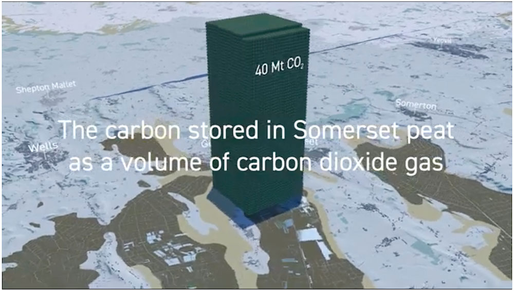
Animations about Somerset’s peat, and Floodplain connections
To further stimulate debate, the project team also worked with data visualisation experts to produce two animations, about Somerset’s Peat and Floodplain Connections.
The first piece explores the value of keeping peat wet and in the ground, the second looks at taking a balanced and careful approach to re-connecting rivers to floodplains.
Both videos relate to activities covered elsewhere in this annual report, such as peat trials (W2) and schemes such as the ‘Stage 0’ works on the National Trust’s Holnicote estate, the Merriott Stream de-culverting, and the wetland creation at North Brewham.
Both videos are on the Adapting the Levels YouTube Channel.