Grants given by SRA to Somerset communities
Fifteen grants have so far been awarded to places across Somerset through the Somerset Rivers Authority (SRA) Community Flood Action Fund (CFAF).
The purpose of these grants is to help people with good local knowledge of flooding problems take practical actions with obvious benefits that can be achieved quite quickly. Grants offered are between £3,000 and £20,000.
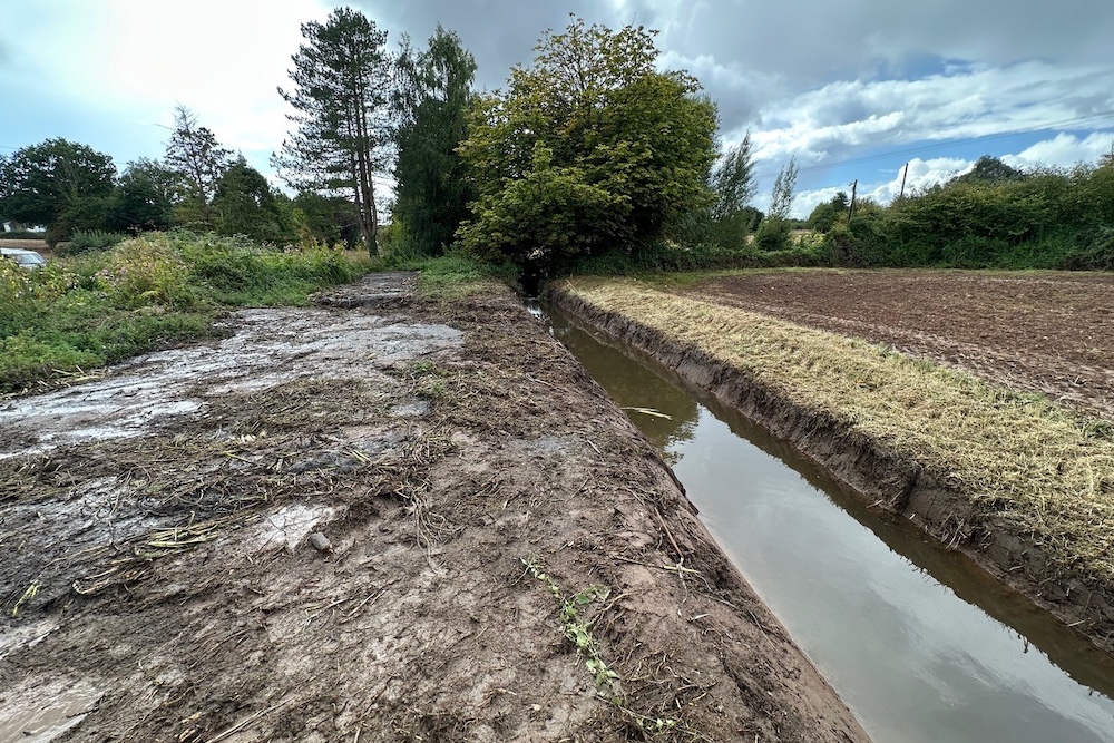
The photograph at the top of this page shows a watercourse desilted for West Buckland Parish Council’s Asham Lane flood relief scheme in the hamlet of Ham. Thanks to local resident Sue Singleton for the photograph.
Read a case study about the flood relief scheme in Asham Lane in Ham, which is near Wellington.
Successful applicants
The seven successful applicants in 2025’s first round of bids were:
West Camel Parish Council: river maintenance, £5,000. A project to desilt and remove debris from the River Cam near Higher Mill in West Camel to increase the river’s capacity and reduce flood risks, especially to properties in Fore Street, Back Street, Parsonage Road and places downstream of West Camel. This should also help to keep roads open during periods of heavy rainfall. The aim was to reverse years of non-maintenance and thereby make future upkeep easier and less expensive and arduous. A project led by the parish council, involving volunteers, landowners and farmers. In recent years, West Camel has had regular experience of unwontedly high water levels.
Long Sutton Parish Council: Knole community flood relief scheme, £15,466. An underground drainage pipe has been installed to help reduce flood risks at Knole near Long Sutton, where nine properties (out of a total of 40) flooded over the winters of 2023-24 and 2024-25. This drainage scheme also included the construction of concrete block inlet and outlet headwalls, ditch deepening and widening, roadside grip installation, and anti-scour protection. One particular aim was to reduce surface water flooding along Grove Lane and land to the south, as well as lessening pressure on ditches to the west. This scheme is part of a series of works funded by the SRA in and around Knole, based on a February 2024 Flood Risk Identification Report commissioned by the Parrett Internal Drainage Board. For example, see the section about natural flood management flood works at Manor Farm and St Benedict’s Farm in Knole (you will need to scroll down this page, which is from the SRA Annual Report for 2024-25).
West Monkton Parish Council: Blundells Lane flood alleviation project, £7,300. A project to reduce flooding along Blundells Lane in West Monkton, chiefly to help maintain access for local people and businesses (for example, in units at Prockters Farm and the Orchard Business Park, and the restaurant at The Monkton Inn). The parish council’s application outlined three main stages of activity:
- cutting back hedges and verges over the ditches on Blundells Lane from its junction with Red Hill and The Street to its junction with Monkton Heathfield Road;
- then clearing and de-silting these ditches so more water can flow into the culvert under Monkton Heathfield Road and then continue into Dyers Brook, rather than flooding Blundells Lane;
- clearing gullies along Blundells Lane and where possible developing ditch banks.
All these works were proposed for the autumn so as not to disturb any nesting birds and to maximise benefits for rainy winter months.
Creech St Michael Parish Council: Mill Lane flood pump, £19,483. A project to provide a permanent pump to reduce flood risks in Mill Lane, Creech St Michael, to help protect homes and businesses at the Mill Lane Business Park. The pump will be managed, serviced and maintained under the auspices of the parish council, which has also pledged to have available at all times a team of at least four volunteers trained and available to operate the pump. The background to this application is that in 2009 the Environment Agency installed the necessary infrastructure – chiefly a channel to divert water into the River Tone – and since then the Environment Agency has consistently provided a pump in times of need. Recently, however, the parish council told the SRA, the Environment Agency has made residents aware that the provision of a pump cannot be absolutely guaranteed, as national and regional needs must also be considered. Concerned that a pump might one day be unavailable, the council was therefore keen to remove that uncertainty by getting its own pump, thereby helping to protect properties in the Mill Lane area.
Cotford St Luke Parish Council: flood plan, £15,000. Cotford St Luke has existed as a village for about 25 years: it used to be the site of a Victorian asylum. Part of Cotford St Luke’s infrastructure is a flood defence system made up of culverts, ditches, pipes, attenuation ponds and a floodplain. The parish council told the SRA that as none of this infrastructure was ever adopted by the local authority, it was not consistently maintained and so had fallen into disrepair. The council added that some ditches and culverts had been sporadically cleared by their owners, in response to requests from residents and the parish council, but villagers were now keen to take a more wide-ranging approach, and get their flood defences working well as a system. Proposed works therefore included:
- jetting of pipes that feed water into attenuation ponds and onto the floodplain
- clearing attenuation ponds
- repairing a bridge that allows walkers to cross the stream that runs through the floodplain
- amending the ditch and culvert system to re-incorporate a currently dry culvert
- removing dead and diseased trees from the floodplain
Stoke St Mary Parish Council: Stoke Road (West) / Stoke Lane to Hayden Lane (Lower), flood control and mitigation, £12,000. A project to reduce flooding at two difficult hotspots in the parish of Stoke St Mary, chiefly to reduce flood risks for people’s homes and to help maintain access to and from the village, which in recent years has sometimes been cut off. The parish council successfully tackled many problems, by buying equipment and getting volunteers to clear out more than 110+ drains, culverts and roadside ditches. An SRA CFAF grant was given to address two challenges which were currently beyond the council’s scope. Firstly, a comprehensive programme of clearing and bringing back into service, drainage channel and inflow ditches from the junction of Stoke Road and Stoke Lane to lower Hayden Lane, so that water can flow as it should into Broughton Brook. Secondly, widening and landscaping two existing drainage channels that run from west to east either side of New Barn Farmhouse, intended to take the overflow from the M5 drainage ditch when it is overwhelmed by the flooding of Stoke Road and land between Stoke Road and Hayden Lane. Once these works have been done, the parish council has pledged to maintain them and allocate necessary funds from its parish precept.
West Buckland Parish Council: Asham Lane flood relief in Ham, £3,100. A project to reduce flood risks along Asham Lane, which flooded more than 10 times in 2024, chiefly impeding access. Read a case study about the Community Flood Action Fund Action grant for flood risk reduction works for Asham Lane.
The five successful applicants in the second round were:
Ruishton and Thornfalcon Parish Council: Lower Henlade ditch clearance, £3,993. In Lower Henlade, Ruishton & Thornfalcon parish council was given £3,993 for clearing debris, silt and vegetation along 230 metres of watercourse in Lower Henlade to benefit properties, small businesses, and roads.
Baltonsborough Parish Council: Coxbridge Brook weed clearing and flailing, £3,600. Baltonsborough Parish Council was given £3,600 for flailing and weed-cutting along the overgrown Coxbridge Brook, to restore its capacity and reduce flood risks to homes in Baltonsborough, Coxbridge and West Pennard, where there were floods in December 2023 and February 2024.
Croscombe Parish Council: New manhole in River Sheppey culvert at Long Street, Croscombe, £19,519. In Croscombe, where 20 properties flooded in February 2024, the parish council was allocated £19,518 to create an access chamber into the River Sheppey culvert near the village centre. This chamber will help Flood Group volunteers to remove debris and blockages from a sticking point where the culvert bifurcates. This will reduce the risks of water backing up and overflowing, so helping to protect homes, the village pub and the A371.
Godney Parish Council: Decoy Rhyne – bank stabilisation and maintenance, £19.510. Godney Parish Council was awarded £19,510 for partially desilting Decoy Rhyne and James Weir River, restoring the north bank of Decoy Rhyne and sealing leaks. The council was keen to reduce troublesome overflows of water northwards towards North Drain, thereby benefitting homes, businesses, farmland, wildlife habitats and roads, and meaning less water needs pumping from North Drain into the Brue.
Norton Fitzwarren Parish Council: Norton Fitzwarren riparian maintenance, £14,448. In Norton Fitzwarren, the parish council was allocated a grant of £14,448 for maintenance works such as debris removal and de-silting along Norton Brook and Halse Water to reduce flood risks at Norton Manor Camp (40 Commando Royal Marines), Manor Lodge, Ford Farm, Ford Cottages, Wassail View and the B3227.
The three successful applicants in the third round were:
Isle Abbotts parish council: dredging Badbury ditch, £14,040. A project to desilt 90 metres of a roadside ditch near the Badbury T-junction in Isle Abbotts, at the bottom of Lower Woodlands Lane and Garden Plot Hill. When this junction floods, the road becomes impassable to all vehicles, which is a problem because it is one of the two main routes in and out of the village. Flood water also backs up along Woodlands Lane, Garden Plot Hill and Ilminster Road. The parish council told the SRA that after this roadside ditch was desilted by Somerset County Council in 2014, there were no incidents of flooding for five years. Once works have been completed this time round by the parish council, Somerset Council’s highways department has said it will jet blocked drains at the T-junction, to help further reduce flood risks for people, properties and roads.
Carhampton Parish Council: culvert clearance, £12,950. A project to desilt two culverts in Carhampton, Stoney Bridge beneath the A39, and Eastbury Bridge beneath the B3191. The parish council told the SRA that an estimated 15 tons of silt needed to be removed from these two structures, to restore their capacity for conveying water downstream. Doing this would help to reduce the risks of water overtopping and flooding busy, important roads. (For example, the A39 was blocked on 17 September 2023, when Butlin’s at Minehead had to be evacuated because of flooding). Beneficiaries of this project are therefore expected to include residents, businesses and road-users.
Ruishton and Thornfalcon Parish Council: desilting Gabrieli pond, £3,593. A project to desilt an ancient seep pond, known as the Gabrieli pond, as seen on an 1843 tithe map (which is the earliest known detailed map of this area). The pond is at a critical point in the landscape where it could help to slow the flow of water down to roads and homes in Lower Henlade. But its silt levels have got so high that – during periods of heavy rain – water instead pours down a pipe, into a ditch, and then into another underground pipe from which it spurts out so fast into the Lower Henlade village ditch that it also flows out onto the road. This pond desilting project is intended to complement the Lower Henlade ditch clearance for which a CFAF grant was given in round two (see above).